OmniCore Location Services
OmniCore Location Services adds real-time AVL and GPS tracking directly inside the OmniCore dispatch console. It aggregates location data from multiple radio protocols and manufacturers onto a single map, with configurable geofences including blast, no-go, speed, and confinement zone types for demanding industrial and public safety environments.
Overview
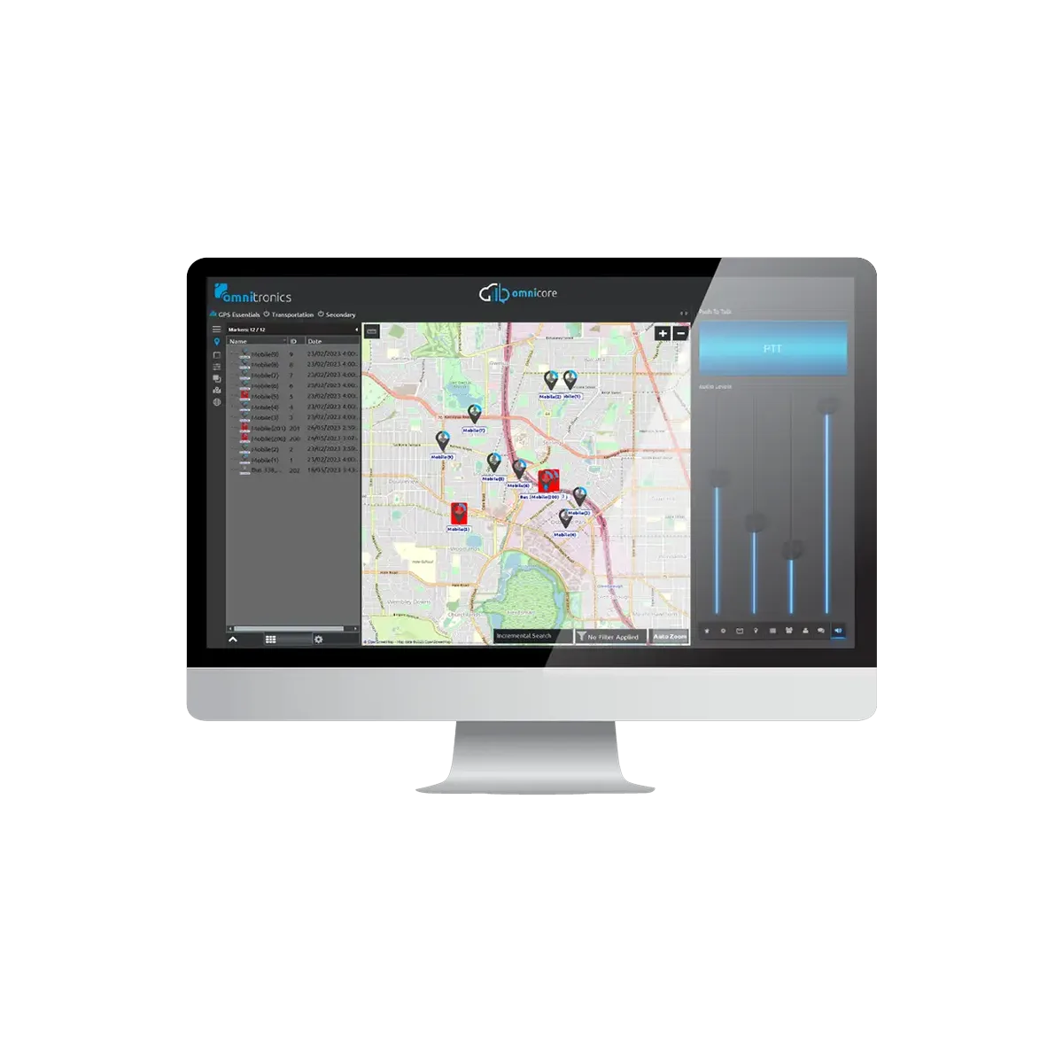
OmniCore Location Services is an AVL and GPS tracking module that integrates directly into the OmniCore dispatch platform, giving dispatchers a live view of field personnel and vehicle positions without switching to a separate application. GPS data is pulled from digital radio networks via Omnitronics Digital Radio Gateways and aggregated onto a single configurable map across P25, DMR, NXDN, and IDAS simultaneously, regardless of radio manufacturer or protocol. Dispatchers see every unit on one screen, with identity icons, position timestamps, and route history all in one place.
Geofencing goes beyond simple circles. OmniCore Location Services supports No Go zones, Speed zones, Yard zones, Site zones, Confinement zones, Blast zones, and Emergency zones, making it directly relevant to mining operations, utilities, and public safety agencies that need context-specific geographic controls. Alert conditions are configurable per geofence and push to all operator positions in real time through the central ALS Server. Route history and breadcrumb trails are viewable in the ALS Viewer for post-incident review.
Unlike competing platforms that charge separately for mapping and AVL functionality, OmniCore Location Services is offered as a straightforward add-on to OmniCore Enterprise or Express with no hidden licensing conditions. Direct manufacturer partnerships allow the system to interpret proprietary GPS data formats from multiple radio vendors, which is a technical requirement most mapping platforms cannot satisfy without manual data conversion.
Key Features
Multi-Protocol GPS Aggregation
Combines GPS data from P25, DMR, NXDN, IDAS, and other protocols onto a single unified map through Omnitronics Digital Radio Gateways. Direct manufacturer partnerships enable accurate interpretation of proprietary GPS data formats from Kenwood, Motorola, Tait, and Hytera radios.
Advanced Geofence Types
Supports No Go, Speed, Yard, Site, Confinement, Blast, and Emergency zone types, covering the full range of industrial safety and public safety geographic control needs. Geofence alert conditions are configurable per zone and pushed instantly to all operator positions through the central ALS Server.
Route History and Breadcrumbs
Breadcrumb trails record the full movement history of field units with timestamps for post-incident review and compliance documentation. The ALS Viewer provides advanced route playback with configurable time window selection.
Integrated Console Map Display
Location data appears directly in the dispatch console interface with no separate application to manage. Dispatchers access key dispatch functions from the map view itself, and pre-defined location areas give quick access to frequently monitored sites.
Interested in the OmniCore Location Services?
Our team can help you choose the right configuration for your operation. Call us or fill out the form.